San Solomon Springs to Fort Davis, TX
Trip meter (car 120 miles)
The wash in spring water wasn't quite what I thought. As much as I really worked at the squeegee, and the microfiber towel, the bus is, well, spotted. Have to revise my thinking about the quality of the water in the pipes here at Balmorhea Springs.
Today Joan and I packed a lunch, and took a trip in the car. South on State Route 17 32 miles to Fort Davis. We found this very nice wayside picnic area just outside of the town of Fort Davis
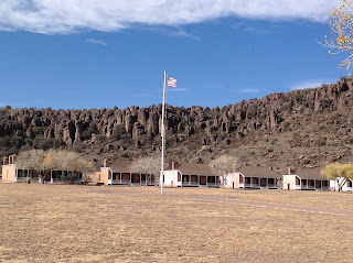
Fort Davis was first established in 1854. The first establishment consisted of wood building and thatched roofs. The fort was located along the supply route from San Antonio to El Paso, protecting emigrants, freighters, mail coaches and travelers, from bandits and native American tribes of Apaches, Comanches, and Kiowas. When the Civil War broke out Texas went with the Confederacy and the US Army with drew from Fort Davis in 1861, only to take it back in 1862. After the War was over the fort lay deserted for 5 years. June of 1867 a new Fort Davis was established on the grounds of the old fort, and that is the one we see today.Here is a picture of the officers houses. Starting in 1963 the Park Service has been working to turn back the hands of time
This picture is of a restored barracks building complete with period gear and beds. Some of the buildings at the fort were dismantled and used for building materials before the NPS took over. This foundation is all that is left of a kitchen and mess hall Joan and I toured the fort grounds for about 2-1/2 hours before we felt like we had seen what we wanted, including the old hospital, stables, magazine building and the foundations of the first fort-many of which still exist, even though they were built with sun baked mud brick! Here is a two story mud brick building that is now being preserved in it's present condition. After getting an ice cream cone at the local Thriftway we felt up to more exploring. Jim and Sally have told us Alpine is one of their favorite places so we decided to drive the 23 miles South to see it in person. Alpine turns out to be a very nice little town of 6000 people tucked up against the Del Norte Mountains. To round out the trip we drove west 34 miles to Marfa which put us back on Route 17 and a straight shot back to Balmorhea Springs. We know most of you have heard of the Marfa lights- well check out this street sign. They actually have a very elaborate viewing structure that you can use to watch for the zipping, flashing, colored light show.As we arrived back at Balmorhea, I begged Joan to let me run up to see Balmorhea lake only 5 miles away. Turns out this was a very bad idea that got worse and worse. We made it to the lake on a rough 1-1/2 lane semi-asphalt road out of town. The lake is not very spectacular. The map on the iPad showed a road all the way around the lake and after some wheedling I got Joan's okay to circumnavigate the lake on a rutted gravel road. Well the road kept getting worse and worse.
We ended up on a very narrow 4 wheel drive track that dead-ended at an irrigation canal, and had to back track two or more miles with thorns tearing the finish on the car on both sides! I'm in the dog house for that one.Here are some photos of a swim I took in the pool here at the park yesterday
The water is from a fresh water spring in the bottom of the pool and stays 72 to 76 degrees all year round. Only part of the pool has a concrete bottom, at 5' and the rest is all natural rocks and sand, and about 25 feet deep. There are fish in this pool and they don't appear to be afraid of you! Off to Odessa tomorrow, in hopes of getting a proper fuel filter to save our injectors. Jeff and Joan


Comments
Post a Comment