Odometer 55460
Trip Miles 98 miles
In our desire to see more of each state we visit, we were actively looking for alternative to going up Interstate 5. Longtime readers already know that I really dislike driving on the interstate highways. Interstate is very intense driving and space management keeps you from seeing any of the scenery-. if there is such a thing on an interstate corridor.
For these reasons, we choose a route which will take us from Bakersfield up state highway 178 to Lake Isabella, and from there continuing east over to US 395.
 |
| California Route 178 Rocks hang over into your lane |
The decision to take Cal 178 was a chancy one. The highway follows the Kern river up a very tight canyon. There are very tight curves and there is one 2 mile section where the canyon walls intrude into the travel lanes. The road is plastered with signs warning truckers of the hazards, and advising alternative routes. Gulp! We forged on, but very carefully. Auto drivers coming down the canyon towards us looked with astonishment as we came around each blind corner. The overhanging rock was the most challenging and that went away after the first several miles. From that point on it was just a very narrow road with no shoulder and tight turns.😊 The scenery was spectacular! This section of road climbs very steeply up the canyon from 400 feet of elevation to over 2000 feet.
 |
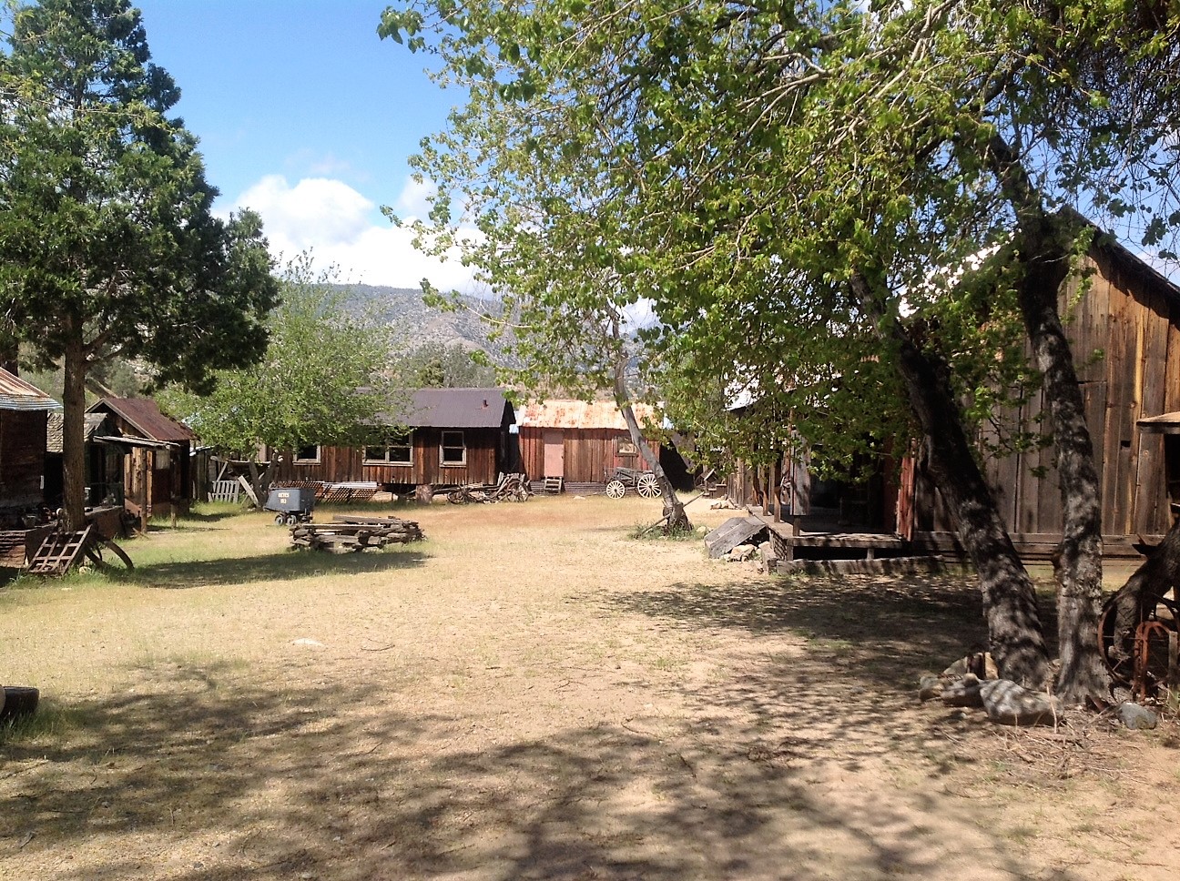
| Ghost Town recreation at Bodfish, CA |
Just before we got to Lake Isabella Joan spotted a sign advertising a ghost town and wanted to take a look. Welcome to the Silver City Ghost Town...
 |
| Cabins original to this area at Bodfish |
Turns out this is a construct. A local family started saving and moving old buildings to this site, and it is quite the collection. Each has a history...
 |
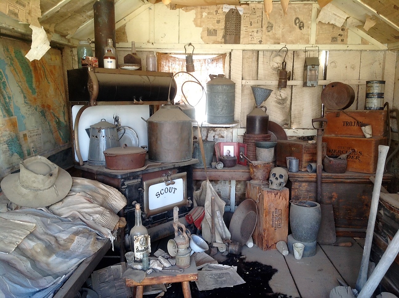
| Miners Cabin at Bodfish |
This one is supposedly a miners cabin, and it looks very much like I'd expect one to look. We toured the site for a few minutes and also the antique shop that adjoins the "Town".
 |
| Lake Isabella, CA |
As we left Bodfish for the highway we passed through the small town of Lake Isabella. There was a fishing derby on that has attracted a huge crowd to the lake shore, and the bait and tackle stores were doing a very good business.
The highway from Lake Isabella over to 395 is wide and fairly flat gaining only about 500 feet in elevation
I has been windy since we left the lake, however it has been a tailwind in our favor. Once we reached 395 and turned north, the wind became a side wind, and the gusts were very strong.
 |
| CHP issues a high wind advisory and closed down US 395 at Pearsonville spilling us out into the desert |
We hadn't gone very far, maybe 16 miles down US 395 when we came to a CHP roadblock and they were closing the road to all large vehicles, trucks and RVs in particular. We didn't know it then, but we were actually at a place called Pearsonville. There was a Shell gas station with convenience store and Subway sandwich shop. The only other things we could see were a wrecking yard and an abandoned race track (cars we think).
 |
| At home in the desert- here for the night |
We were obliged to find a place in the desert and hunker down until the wind advisory was lifted. It was 4 PM so we found a place where we could head into the wind and set up for the night. If the advisory was lifted soon- we didn't care, we were here for the night- Stories circulated that it could be 8 PM or even 10 PM before traffic could resume, however when we went to bed at 10:30, everyone was still here.
 |
Inverter working again!
Wonder of wonders, we looked over at the inverter panel and it was alive! Don't know why or how, but it's functioning again. One poster on the Internet forums suggested that our batteries are too old (he's right 6 yrs+) and are not charged up enough for the inverter to recognize them and turn on? Don't know, but it is plausible that running down the road to day we put enough of a charge in them from the Cat's alternator to have the inverter turn on again.
 |
High Wind Advisory on US 395
|
The next morning we were up at 7:30 AM and the "parking lot" was empty. All the big rigs and 95% of the RVers had headed north. Cheesh! what's the hurry? We are retired and this is what we do- so why get in a big rush. After a leisurely breakfast and coffee we packed up and joined the world on US 395 north.
It wasn't long before we started seeing overturned trucks and trailers that most likely prompted the highway closure.
Stay tuned for part two below
Carson City, NV
Odometer 55745
Trip 285 miles
Last night we had intended to stay overnight in Lone Pine, but seeing as how we never got there, we re-adjusted the pins on our map and set our sites on Carson City for tonight. Setting out from Pearsonville this morning that meant almost 300 miles and we have worked up to, and were set for, a more normal day of driving (6hrs).
 |
Abandoned PPG Plant on Owens Lake near Lone Pine, CA
We passed through little communities with names like Little Lake, Coso and Coso Junstion, Haiwee, Grant, Olancha and Cartago, always wondering what had brought this community to life, and why did it disappear. When we got to Owens Lake my curiosity was roused by and old defunct factory and a lot of work happening in the dry lake bed. According to one document issued by the US Geological Society the Owens dry lake bed is the single greatest source of particulate dust smaller than 10 microns, in the United States. It was not always so, in the 1800's and into the 1900's the lake averaged 7-15 meters deep. Steamboats once hauled ore across the lake from mines in the Inyo mountains. Los Angles tapped the lake for water in 1913 and by 1926 the lake was dry.
The lake bed has high concentrations of Sodium Carbonate, Sodium Bicarbonate, Sodium Sulfate, and of course salt Sodium Chloride. A combination of Sodium Carbonate and Bicarbonate and water make a substance called Trona. Owens lake is the third largest trona deposit in the Americas.
The "factory" I'd seen, PPG built a plant in 1928 to harvest trona from the lake bed and extracted soda ash for glass making up until 1967. There is still a lot of harvesting activity in the lake bed- but it is now processed somewhere else.
|
|
 |
Lone Pine, CA
|
Lone Pine was our original destination last night before the high winds caused a closure of the highway. Cute little town and a favorite of RVers. Originally established in 1861, by 1870 it's main activity was to support the mining activity of the region. Lone Pine had become famous for other reasons too. It was the starting place for the USGS survey team which in 1864 determined that nearby Mount Whitney was at 14,505 feet of elevation the highest point in the contiguous 48 states. It became a rail hub in 1883 when the Carson and Colorado Rail Road came to town, and it became a favorite location for Hollywood films starting in 1920 with a silent film called The Roundup. The movie companies are mainly interested in a location outside of town called the Alabama Hills which most of us have seen in the more than 400 movies filmed there
.
 |
| A Panorama of the east side of the Sierra Nevada Mts. |
It doesn't show well here but I took this panorama shot of the east side of the Sierra Nevada mountains between Lone Pine and Bishop- It's awe inspiring in person!
 |
| Lee Vining, CA "Gateway to Yosemite" |
The small town of Lee Vining, is well positioned at the eastern portal to Yosemite National Park, on the shores of nearby Mono Lake, and a few miles from the famous ghost town, Bodie.
The road to Yosemite is closed due to snow this time of year and Bodie is a State Park and is currently closed for a survey of possible earthquake damage from an earthquake centered around Hawthorne, NV.
Rats! We really wanted to visit Bodie.
 |
| Schatz Bakery |
By the time we arrived in Bishop we were plenty hungry, and we'd heard about Erick Schat's Bakery and wanted to eat there. We were not allowed to film in the interior of the bakery, but suffice to say it is jammed with all kinds of baked goods on racks and in cases in every square foot. We both had sandwiches and soup both of which were delicious. We bought a loaf of raisin bread, and their famous sheepherder's white bread to take home with us. Bishop is a pretty little town and I want to come back and spend some time here.
Just outside of Bishop, the highway starts to climb, I mean really climb. We are geared down and pedal down to keep 35 mph. The grade rises 1765 feet in less than 6 miles
 |
Near Bishop, CA
 |
We saw this good idea. In one of the windy areas the highway department has set up wind socks to allow drivers to determine the ferocity of the wind in a visual warning system.
 |
| Conway Summit 8143 feet highest point on US 395 |
Finally we make the summit at 8143 feet the highest point on US 395 and the highest pass we will traverse this trip home.
 |
| Topaz Lake |
A hour up the road from Bishop is Topaz Lake, and the little town of Topaz, Lake. This place is interesting because the lake and the town are split by the border of Nevada and California. At an elevation of 5,080 feet (nearly a mile high) we have descended 3,000 feet to get here. In 1922 the Walker Irrigation district diverted the nearby walker river into a smaller natural lake to get this giant reservoir nearly 3-1/2 miles long and 100 feet deep.
 |
US 395 through Inyo National Forest
The first tall timber we have seen on our trip north- big Ponderosa pines.
|

We arrive in Carson City for the night. We checked into Silver City RV Park and enjoy the sunshine. As soon as the sun sets it will get cold up here at 4,800 feet.
Your Traveling Friends
Jeff and Joan


Comments
Post a Comment