Thursday, January 31, 2013

Sunshine and Barbeque

Odometer 28240

Trip meter 0

As promised, the skies were clear and the temperature was cool this morning in Waveland, MS. Joan and I did chores this morning, and as a reward we decided to go to The Shed Barbeque and Blues Joint for a late lunch. The Shed is in Gulfport about 30 miles east and a few miles inland, so it took us the better part of an hour to traipse up the coastline (sightseeing) to get there. The drive was worth it!


The food was excellent and we ordered a sample platter that included all 7 of their featured meats, so we could have a lot to take home for tomorrow's lunch ( and maybe dinner?)


On the way to The Shed we passed an outlet mall,so on the way back we checked out the shops, and my idea to get a bikini for Joan backfired- but all was not lost, as I found some shorts and a couple of polo shirts I liked.

On our way down South Beach Road to home we noticed this cool cloud pattern. It should make for a great sunset!


We got back to Waveland just in time for for another beautiful sunset- magnificent!


We like it here, we will definitely stay a week or so to relax and explore.

Jeff and Joan

Mississippi Gulf Coast

Odometer 28240

Trip meter 173 miles

Tuesday night's weather forecast was for possible severe weather overnight with winds kicking up before we went to bed, so we pulled in the slide-outs on the motorhome to make ourselves a smaller target, and have less canvas in the breeze. The report predicted the cold front would hit at 3 AM and with rain, thunderstorms, and more wind- and they were right almost to the minute. Not being used to storms like this one, I lay awake for about and hour, Joan was awake much longer, while it passed over. Tornadoes were only a slight possibility for our area, and as predicted they went north and east of here.


Poche's RV and Fishing Camp and Breaux Bridge, Louisiana were very nice, but we were anxious to get back to the Gulf coast. After breakfast we secured for travel and headed for Breaux Bridge to see about filling our propane tank. On thing we've noticed in our travels is that propane can be hard to find, and when you do find it, it's not usually at a gas station. The folks at Poche's told us we could get propane at L&L Tire so we set a course with the trusty iPad and motored off into town 6 miles away. We came up on L&L located on a busy 4 lane road and immediately my alarm bells went off telling me this didn't look good. I couldn't see a propane tank, and couldn't see a circle drive. We had about a second to decide go-no go on turning in, and we decided we needed the gas so I turned in. Fist thing we noticed is that there is no curb cut at the (gravel) driveway so we crashed over a lowish 3" curb and into a pot-holed gravel area with many 3-4 foot puddles of standing water. Next thing we noticed was that the driveway dead-ended at the rear shop. Still no propane tank in site. I parked in the gravel drive and walked to the front of the tire shop. This is no Les Schwab, none of the employees looked up, said anything to me, even looked interested in helping me, so I went to the office and a very nice young lady there informed me that I'd have to unhook the car and back over behind the back shop where the propane tank was, and she'd have someone come fill my tank. Not to belabor the story here we did eventually get the tank filled, get the car hooked back up, and gingerly made our way back out to the street where we blocked two lanes of traffic as we slowly negotiated the curb. We had decided earlier that we would take interstate 12 east to the Mississippi state line- a good choice seeing that it was grey and windy, and nearly noon.


Many of the highways we have been on are poured concrete with slab joints that set the coach to thudding one-to the next. Today on I-10 was no exception. We were not on the interstate very long before we started to cross the Atchafalaya Basin, which we later found out is the largest swamp in the United States. Get this, the bridge is 18.5 miles long! Each direction had it's own bridge so there are two parallel bridges elevated 20-30 feet out of the swamp.

We couldn't help but wonder what the cost per mile was for building this structure. The construction was first class with large concrete pilings and extra wide concrete roadway. Very nice!

Just before we entered Baton Rouge, we crossed over the Mississippi River- a first for Joan! She has never been this far east, having traveled to Minnesota when she about 13 years old, and seeing, but not crossing the river.

The recent rains both here and further north, have kept the river full. Grey skies make for grey pictures (sorry)

Baton Rouge is just over the bridge on the east bank of the river, since we were not stopping here this time, Joan snapped a photo of downtown BR from the moving bus.

Around 1:30 in the afternoon we were getting a little peckish, and the small town of Walker looked to offer some fast food fare of interest. We had salad and a sandwich at the Jack and were able to circle around behind a grocery store and get back to the freeway entrance without having to unhook again.
Louisiana is not a wide state- only 250 miles wide at this latitude, and since our whole trip today is only 160 miles to Waveland, MS, we soon saw this welcoming sign.

Soon after entering Mississippi, we turned in at the welcoming center, a large, gracious estate house on manicured grounds, where we picked up maps and brochures for our explorations.

Within minutes we had arrived at our RV park, Buccaneer State Park. This park was devastated in the Katrina hurricane, and got wet again in hurricane Ike. They have rebuilt and are just now re-opening.


The blog wouldn't be complete without a sunset picture. We took a quick site seeing tour after setting up the motorhome, we drove the car up the beach a few miles. Can't wait til tomorrow- sunny but cool in the 50s and 60s.

Jeff and Joan

Tuesday, January 29, 2013

Tabasco anyone?

Odometer 28,063

Trip meter 116 miles

Tabasco sauces are made at Avery Island, Louisiana and we are off to see the factory today on our way to Breaux Bridge. Our friend Richard Burris, in Rockport, suggested an RV park named Poche's near Breaux Bridge about a hundred miles from Myers Landing where we were last night, and we are anxious to check it out. It just happens that Poche's is a Passport America park and that means as members we can stay for 1/2 off- Score!

The roads in rural Louisiana have two things in common.

The roads don't have any shoulder at all, and they are patchy and bumpy by-and-large. Some of the concrete slab roads near Lafayette were so curled as to launch us in to a bounce-bounce-bounce cadence for miles at a time. We wondered how the poor coach could hang together- everything in it sure got pureed.

We were following our GPS routing to Avery Island when we suddenly rounded a curve to see signs telling us that the road had been closed. A local told us it was due to a bridge being out of service- and that we'd have to turn around.

Any of you that follow this blog know by now that is not an easy task for a 36.5 foot motorhome and toad.
    The process is to: Stop in the middle of your lane,
    Get into the towed car and set the handbrake
    Disconnect the safety cables by opening the quick link on each side
    Undo the clips holding the Tow Defender (protection barrier) between car and MH and roll the cloth up and secure it.
    Unhook the airline for the braking system.
    Unhook the lanyard to the break-away switch from MH to the car.
    Pull up on the levers on the tow arms to release tension
    Remove the locking pins at the ends of the tow bar arms at the car
    Back the car away
    Turn the motorhome around and
    Reverse this process to hook the car up again!
To say that we avoid this at all costs is and understatement. We got turned around and a very nice man heading to the lake with his son stopped to see if he could help. He gave us alternate directions that got us around the bridge closure. Two more people stopped to ask if they could give us directions. What friendly people!

We arrived at Avery Island at a little before noon, and since the next tour didn't start till noon, we had a quick lunch of soup and crackers before heading to the factory.

The tour starts with a video telling the history of the island and the McIlhenny family who invented the sauce and started the production.
The actual factory tour is pretty short, after the video we got to see the bottling, and packaging lines and then a small museum of historical facts about the family, the process and the island. One of the most interesting revelations is that Avery Island is a salt dome, and the family has a very large and successful salt mine. Salt domes formed in a line along the Gulf as the tectonic plates drew apart, they can be miles across and many thousands of feet deep. The island vegetation grows in a surface layer of earth 60-80 feet thick.

The gift shop was pure gold!

We had an opportunity to taste all the Tabasco products and there were a lot more than I ever imagined! A short list in in order here. Tabasco coke!- yep, Tabasco Cheez-its- Uhuh, Chiplotle Tabasco sauce, Tabasco Ice cream. We bought Tabasco catsup, Tabasco Steak Sauce, and some Avery Island salt. What a fun side trip!

By 2 PM we were ready to head for Breaux Bridge and Poche's RV.

We started seeing some swamps along our route- the first for this trip, but probably not the last

The park is very large and is mostly lakes, which means everyone gets a lakefront lot!

The weather forecast for tonight is somewhat ominous. A cold front is approaching the warm gulf air that we are currently enjoying. The result will be strong winds, and possible tornadoes- ?? The front should pass through around 3 AM and be gone by tomorrow noon, leaving blue skies and cooler temperatures. The winds are kicking up now and thumping us at 8 PM- should be an interesting night.

Jeff and Joan

Travel has a way of stretching the mind. The stretch comes not from travel's immediate rewards, the inevitable myriad new sights, smells and sounds, but with experiencing firsthand how others do differently what we believed to be the right and only way. -Ralph Crawshaw

Louisiana with a banjo on my knee

Odometer 27,947 miles

Trip meter 194 miles

Sunday the 27th

Before I start today's blog (Monday) I'd like to do a quick paragraph or two about Sunday- our last full day in Galveston. The weather was supposed to be iffy on Sunday so we thought we'd do some grocery shopping, beach combing, and see the Bishop's Palace in downtown Galveston.

The House should really be called the Gresham house as it was built by Colonel Walter Gresham in 1892, and was sold to the church in 1923. Much to our disappointment, we were told during the tour of the house that we could not photograph the interior, which is beautifully finished with mahogany, oak, and walnut.
The house was built with a steel frame and stone exterior, which has helped it survive all the hurricanes since- including the 1900 hurricane that destroyed 90% of the buildings in Galveston. Monday the 28th

We headed out from Galveston today bound for Meyers Landing in Louisiana. A little fun and games before we could get moving. Joan spotted a Valero station yesterday that had diesel for $3.69 a gallon- almost 10 cents a gallon cheaper than anywhere else- but there's a catch. This was a convenience store with the typical tight in-tighter-out- driveway flow that is impossible for a 36.5 foot motorhome with a toad. That can't be enough of a challenge so throw in a pump that only gives 27 gallons at a time- making you run your credit card 3 times to fill up. Well- we took on the challenge! Joan drove the car, I drove the MH- we nearly blocked the entire driveway for 30 minutes while the ran the card 3 times- people were looking daggers at us- mission accomplished! We stopped down the road and coupled the car on to the motorhome and headed for the ferry terminal.

The traffic was light and we rolled right on to the ferry and crossed the ship channel to Port Bolivar. We drove along Texas route 87 towards Port Arthur and the Louisiana border. Route 87 follows the beach so closely we could see the waves hitting the beach, and it proved too much for us- we had to stop! We had a quick lunch and then walked the beach picking up shells and watching the waves hit the beach.

Back on the road we have to make some tracks if we want to get to Meyers Landing before dark. The Valero dance we did this morning getting our diesel saved us $11.25 but it took a fair amount of time too. Our route today is designed to keep us off the interstate and as close to the Gulf as possible. The route also crosses many bays and bayous, some have bridges, but at least two have ferries.

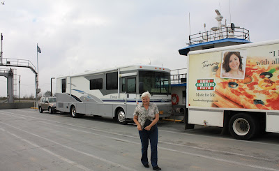
This photo is Joan in front of our motorhome on the second ferry of the day going to Cameron, LA.

The roads in this part of Louisiana are very narrow and have virtually no shoulder, so even if we were tempted we could not have stopped off in between towns. We pulled into Meyers Landing on the edge of Lake Arthur at 4:30 and took a quick tour of the park before we did our set-up on the motorhome.

Turns out that this area has seen some significant flooding in the previous week. We were wondering why most of the ditches alongside the road looked so wet. The woman at the park office showed us the headlines from yesterday's paper and it was all about flooding in the area.
The RV Park is in a area that was spared any damage but the docks are just now coming out from under the water.
No rain on the forecast for the next couple of days thank goodness!

We are planning to visit historic Avery Island tomorrow and stop for the night in Breaux Bridge. Check our blog tomorrow on the power of Tabasco!

Jeff and Joan

Be who you are and say what you feel because those who mind don't matter and those who matter don't mind. - Dr. Seuss

Sunday, January 27, 2013

Exploring Galveston

Odometer 27753 miles

Trip meter 0 miles

Distance from Oregon 3,802 miles

A picture perfect day today. Joan and I took the Toad (towed car) up Seawall Boulevard from our RV park toward downtown Galveston. Why is it called seawall boulevard? Well in 1900 a large storm's tidal surge deluged Galveston killing thousands and doing millions of dollars of damage (in terms of human life it is still the worst disaster in US history). In 1901 the Texas legislature approved the building of a seawall for future storm protection. This first section was 3.3 miles long and 17 feet high. It proved it's worth in 1909 and again in 1915, saving lives and property. It has been extended over the years to 10 miles long. The whole city has been raised behind the seawall- buildings jacked up and filled under-got new foundations. The boulevard runs atop the filled area behind the seawall and allows marvelous views to the Gulf.

We headed toward the harbor side of Galveston to see the Ocean Star Drilling Platform that has been turned into a museum.

Just as we arrived at the pier to go the the museum we were treated to a chance to photograph the Elissa, a 3 masted iron hull sailing ship built in 1877 in Aberdeen Scotland. The Elissa is the 3rd oldest ship afloat. An engine was installed during one of her earlier retrofits.
The museum has many very interesting displays, many of them are models of platforms and the ships that service them.
Here is a beautiful model of the platform we are currently visiting. Platforms come in 4 main categories. The first is the jack-leg style like this one. Large steel legs are jacked down to the sea bed. They can be used in waters up to 350 ft deep. The second kind is the fixed platforms-large erector set legs submerged to the seabed, such as the model in the top left of this next photo. These are used in waters up to 1500' deep.
The third type shown in the museum is the drill ship, shown in the top right of the photo below, which can hold it's place on the surface with precision enough to allow drilling operations at up to 6000 ft deep.
The fourth type of rig is the bouyant spar which is anchored to the seabed with heavy cables- shown in the bottom of the photo below. There are many variants of each type.

Drilling today is more than punching shafts straight down.
This model shows how several bore holes can radiate out from a single site.

By the time we had seen most of the museum it was 1:30 and we were hungry. Lucky for us there was Joe's Crab Shack right on the waterfront near the museum. Joan had her favorite- the fish and chips while I opted for a crabcake caesar salad- both were excellent. We were seated outside on the 2nd story deck overlooking the harbor.
Perfect!

While eating and watching the harbor we got the idea of taking one of the harbor tours we saw passing the restaurant

We hustled down the dock to see where the tour boats were departing from, and quickly found the Dolphin Bay Watch Tours loading for a one hour tour which took us north to the Houston ship channel and back.
The ship channel is very busy with a ship coming or going every few minutes. We also passed Sea Wolf Park on Pelican Island that features the Cavalla, a WWII Submarine, and a destroyer escort ship the USS Stewart. That might make for an interesting stop tomorrow. We also saw the ferry terminal and several of the ferries that take you north from Galveston to Bolivar Peninsula. We will be leaving this way on Monday to head towards Louisiana.
Once back on the docks we headed for The Strand, which is the historic part of Galveston, and conveniently close to Pier 21 where we were.
The streets were crowded on this Saturday afternoon and the Strand was alive with shops offering every imaginable meal, snack or beverage, clothes and more. Many people we passed were carrying beer, wine or cocktails, available from walk-up bars on the sidewalk. We were very taken with the architecture which features quite a bit of brick, stone and cast iron.
Jeff leans on a cast-iron building facade
This is the beautiful Hutchings and Sealy building built in 1895-6 and has survived all the hurricanes and storms since (one of only a few to survive the 1900 storm.) We headed for home via the Seawall stopping at the Orange Leaf for some frozen yogurt, and arriving in time for a stroll on the beach at sunset.

In the end, it's not going to matter how many breaths you took, but how many moments took your breath away - shing xiong

Jeff and Joan

Friday, January 25, 2013

Rockport to Galveston- We're on the move again!

Odometer 27753

Trip meter 196

Our last full day in Rockport was spent with our good friends Jim and Sara. We went to the wetland interpretive area in Rockport to learn more about the birds and plants of the Coastal Bend.

The interpretive area was neatly laid out with gravel paths, and elevated walks. Trees and shrubs were marked with signs for identification.

This picture is a Roseate Spoonbill that was showing its fishing technique for us.
We also caught this pelican napping on a piling.

This same day we visited the Rockport Bay Education Center which is part of The University of Texas Marine Science Institute. The Education Center has a program sponsored by NOAA called Science on a Sphere(r).. The program is presented by projecting images on a 6 foot white sphere suspended from the ceiling.

The 5 projectors overlap seamlessly and can show movement like the rotation of the earth as viewed from space. As a matter of fact some of the photos projected on the sphere were taken from space. The presentation showed how data can be represented in graphic form on the globe. This photo shows the routing of data shared through the Facebook website. The data points are all that is shown- no outlines of any continents were added- the data points make the continental outlines.
After the presentation the presenter left the projectors on so we could take photos and act like Atlas holding the globe- who could resist?

As we packed up and made ready for our departure from Copano Bay RV Park, many of our new-found friends stopped to wish us well and to exchange contact information with us so we can keep in touch. We were quite touched and do hope to see these friends again soon. We understand from others, who have been traveling longer than we have, meeting old friends again down the road is more common than chance would predict.

Galveston

We were ready and rolling down the road first thing this morning (Friday). Of course any of you who have been following us on this blog know that "first thing" for us is about 10:30 AM. We stopped in Port Lavaca for a salad at McDonalds, and again for a stretch break and an ice cream cone at West Columbia on our grueling 4 hour trip to Galveston. We are quite taken with this area, quite possibly because, thanks to Richard Burris, we have a spot in Dellanera RV Park, right on the ocean beach. The sun was setting, and we couldn't wait to get the motorhome set-up and grab a cold beverage and stroll down the beach.

The sunset was glorius.

Tomorrow we will tell you all about our exploration of Galveston and the surrounding area.

Jeff and Joan

Tuesday, January 22, 2013

Friends from Home

Odometer 25557

What fun! Joan and I have had a wonderful reunion with Jim and Sara, good friends from home in Oregon. Jim and Sara are on an odyssey of their own- from their home in Southern Oregon to Arizona to visit relatives, and present some safety training, then on to San Antonio to see their youngest son Chris. San Antonio is only about 150 miles from Rockport, so a rendezvous was a must. They arrived in time for lunch, so we spent Monday eating, drinking and walking the park introducing them around. By now Jim and Sara have celebrity status, because everyone that knows us has heard that we were expecting friends from Oregon to join us soon. After a dinner of shish-k-bobs, and some more wine we talked until we all were sleepy and finally turned in.

Tuesday dawned bright and sunny and the forecast for today was a delightful 70 degrees, so we set out in the car to see the sights. We started with a tour of Allegro Key, a nice waterfront housing development in Rockport where every house is on the water. They can do this because the developers put in miles of canals that connect each back yard to the Aransas bay.
We spotted these white pelicans, basking on the breakwater off Fulton and they kept their perch long enough for us to get a photo.
After the Rockport waterfront we took Texas 35 south to Aransas Pass and then took the ferry across to Port Aransas.
This is one of the shortest ferry rides I've ever taken, but it's fun and FREE- and that makes it cool! The reason for the ferry is that a bridge across this cut would have to be extremely tall or be a drawbridge to allow the ocean going vessels through to Corpus Christi. The ferry just makes more sense.

We arrived in Port Aransas just in time for lunch, so we pulled into Castaways for a bite to eat, and had a delightful time chatting up our waitperson, Tiffany, and getting all the local secrets. All of us ate the fried okra as a side dish to our Black Drum fish , and really liked it. In addition Sara had the pickled okra with her salad, prompting us to decide to find some pickled okra to buy and take home. More on that soon.

After lunch, we drove down to the beach to dip a toe in the Gulf waters and check out the beach.

The water was not warm enough to temp any of us to go wading, but the temperature of the air was great- and very little wind!

A mini-sub caught our eye as we were driving south along North Padre Island, and when I pulled into the parking lot where it was displayed I made a tactical error.

The sub is adjacent to a T-shirt shop that was having a big sale. We ended up with 8 shirts between the two families- but I must admit the prices were great.
The Sub is the brainchild of Bill Gifford, of Gifford Marine Inc. The sub was built in Egg Harbor Township, NJ, started in 2001 and finished in 2005. It is only 33 feet long, and has places for a crew of two. The Needlefish is designed to dive to 300 feet and cruise on two diesel/ electric motors. Bill Gifford owned Gifford Marine Inc., and was a steel fabricator and welder by profession.
No word on how the sub ended up in front of a T-shirt shop in Aransas Pass, I could not find out if the sub was ever used successfully.

We left North Padre Is. via the causeway across the Inland Channel to Corpus Christi. This town has many great shops and we checked out a few of the specialty grocery stores to see if we could find pickled okra and prickly pear cactus jelly. We found the pickled okra but the cactus jelly eluded us.

We arrived back at our RVs in Copano Bay RV Park in time to have a glass of wine and a delicious meal at Jim and Sara's, and then hustle up to the club house to take in a jam session with 11 of our local musicians. We certainly had a good time today!

Jeff and Joan